Export a shading in Eduard
To export a shading to a file do one of the following:
Choose File > Export Shading (at the top of your screen).
Click the Export button in the toolbar.
Right-click on the shading and select Export Shading.
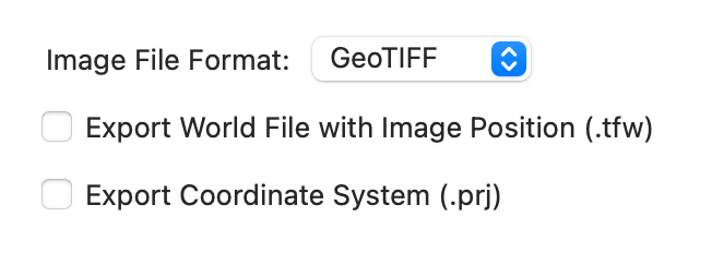
Image file formats
The GeoTIFF format includes spatial coordinate system information. A world file (.tfw) and a projection file (.prj) are optional and only required for software that does not interpret spatial information embedded in a GeoTIFF file. Eduard creates a GeoTIFF file with a lossless compression.
The JPEG and PNG formats do not include spatial coordinate system information. A world file and a projection file with coordinate system information are required for JPEG and PNG formats to define the geospatial location. JPEG uses a lossy compression. PNG uses a lossless compression.
Auxiliary files
Click Export World File with Image Position to create a file with information to position the shading in a spatial coordinate system.
Click Export Coordinate System to create a .prj file with information describing the coordinate system, which may include a projection. Creating a .prj file is not possible if the grid does not contain information about the coordinate system.
Void (or no-data) values
Void grid values are shown with the gray value selected in Eduard > Preferences (in the Eduard menu at the top-left of your screen) > General > Gray for Void Values. If a grid contains void values, you can export a no-data mask to manipulate void values in your GIS or raster editing software:
Choose File > Export Grid (from the File menu at the top of your screen).
For the Grid Format, select GeoTIFF No-Data Mask.
Click Export.
Image resolution
Exported images have the same number of columns and rows as the elevation grid that is used to compute the shading. In other words, Eduard creates and exports one shaded pixel for each elevation value.
See also
![]()