Export a grid in Eduard
To export a grid to a file do one of the following:
Choose File > Export Grid (at the top of your screen).
Right-click on a shading and choose Export Grid.
Then:
Select the file format from Format.
Click Export to create a new file.
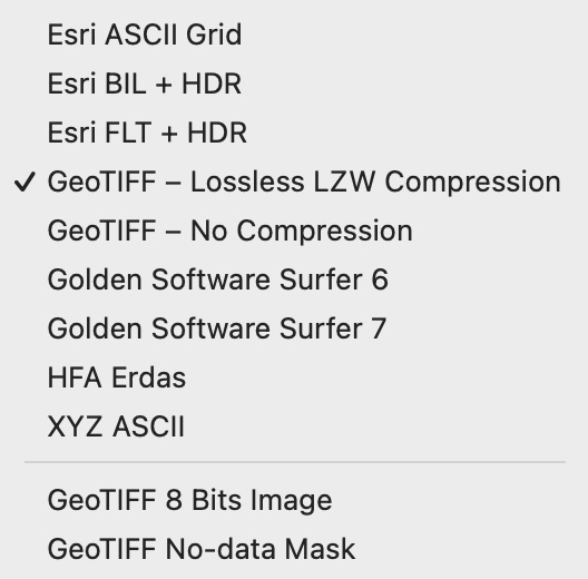
Export formats
You can export elevation grids to the following formats:
Esri ASCII Grid : Large documents. The coordinate reference system is exported to a PRJ file.
Esri BIL + HDR : Medium-size documents. The coordinate reference system is exported to a PRJ file.
Esri FLT + HDR : Medium-size documents. The coordinate reference system is exported to a PRJ file.
GeoTIFF – Lossless LZW Compression : Small documents. The coordinate reference system is embedded in the .tif file. Optional PRJ and world files can be exported with File > Export Coordinate System and File > Export World File .
GeoTIFF – No Compression : Medium-size documents. The coordinate reference system is embedded in the TIF file. Optional PRJ and world files can be exported with File > Export Coordinate System and File > Export World File .
Golden Software Surfer 6 : Medium-size documents (encoding as 32-bit values). The coordinate reference system is not exported.
Golden Software Surfer 7 : Medium to large documents (encoding as 64-bit values). The coordinate reference system is not exported.
HFA Erdas : The coordinate reference system is embedded in the HFA file.
XYZ ASCII : Very large documents. The X, Y and Z coordinates of each grid cell are exported to an ASCII text file. Void values are indicated with -9999.
The recommended format is GeoTIFF format with lossless LZW compression if supported by your other software, because it produces small documents and embeds all coordinate reference information.
If you need a .prj file with coordinate system information for the GeoTIFF, Surfer, HFA Erdas, or XYZ ASCII formats, you can export the coordinate system separately.
When an export creates more than one file, all exported files must be kept in the same directory. Names of exported files should not be changed.
Eduard exports high-precision 4-byte or 8-byte floating point values, except for the Esri ASCII Grid and the XYZ ASCII formats, which use a text format with millimeter precision.
Export a grid to an image file
To convert the grid to a grayscale GeoTIFF image with values between 0 and 255, choose GeoTIFF 8 Bits Image from the format list.
Export a no-data mask
To create a 8-bit GeoTIFF image with a mask encoding void (or no-data) values, choose GeoTIFF No-Data Mask from the format list. This option is only available if the grid contains void values. A no-data mask image can be useful to manipulate void values in a shading with your GIS or raster editing software.
See also
![]()